/ SERVICE #07
Mapping, Orthophoto & 3D Surveying, Geodetic Analysis with UAV Systems
Mapping, Orthophoto & 3D Surveying, Geodetic Analysis with UAV Systems Orthophoto surveying with drones Geodetic surveying with drones 3D modeling and digital terrain models DTM/DSM development of photorealistic 3D reconstructions of terrain, buildings, construction sites, and structures Creation of Digital Twins orthophoto surveying, geodetic surveying, three-dimensional 3D modeling, and topographic mapping, applicable across a wide range of sectors – construction, agriculture, urban planning, environment, security, and infrastructure
Precision, efficiency, and innovation in measurement and visualization of terrains and structures
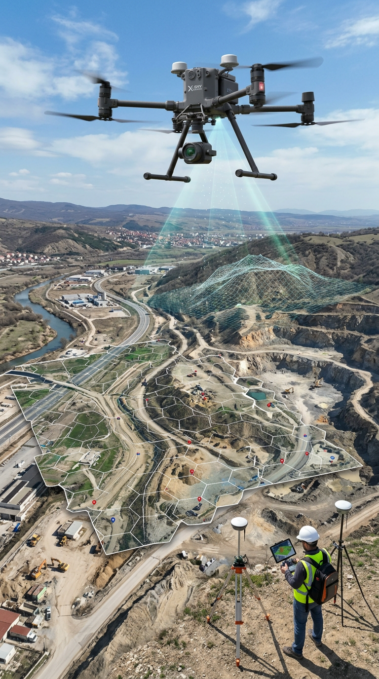
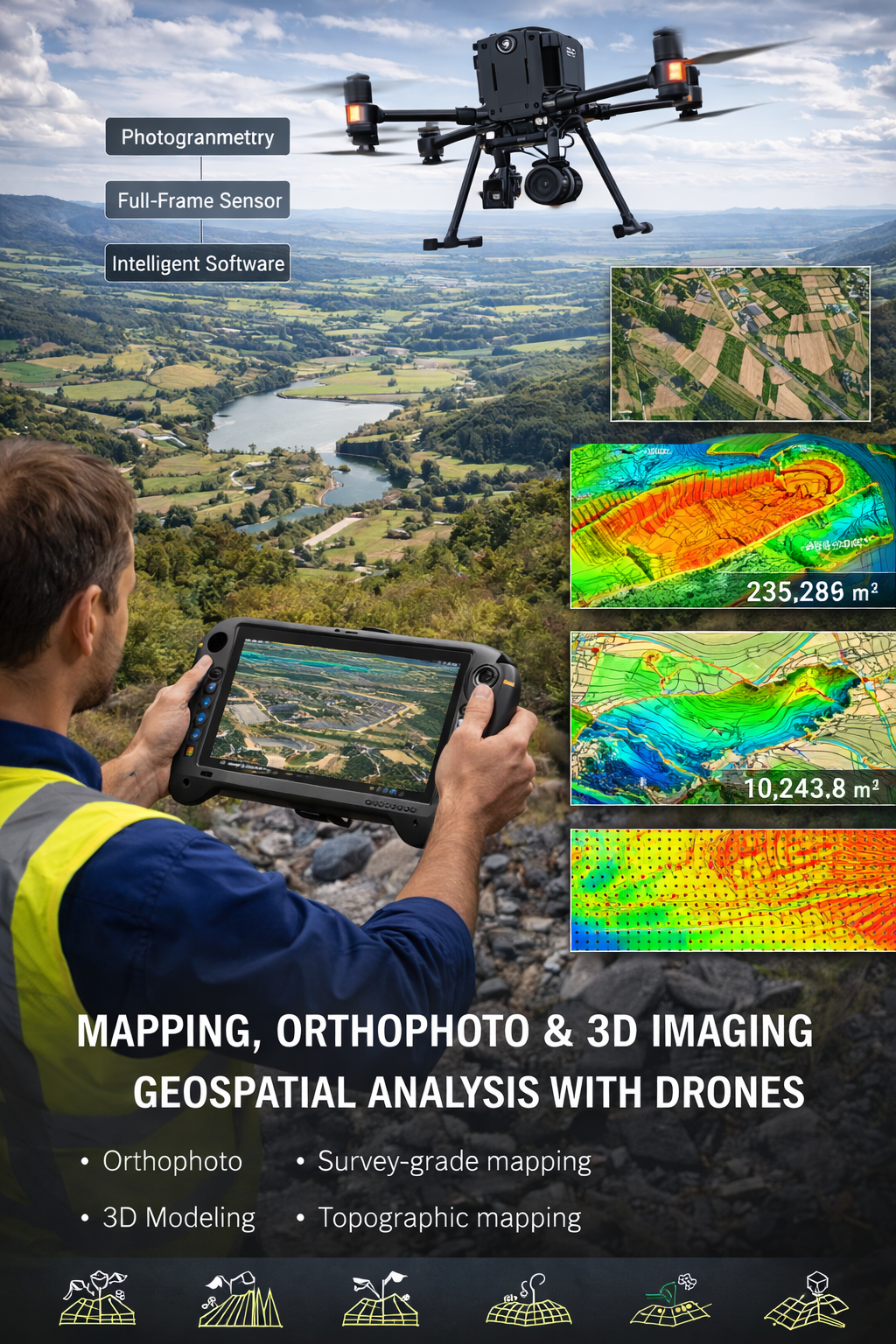
X-Sky Dynamics provides high-tech services in the field of mapping and geodesy through the use of industrial drones equipped with photogrammetric cameras, Full Frame sensors, and intelligent spatial analysis software. These services include orthophoto surveying, geodetic surveying, three-dimensional (3D) modeling, and topographic mapping, applicable across a wide range of sectors – construction, agriculture, urban planning, environment, security, and infrastructure. By combining aerial data with geodetic accuracy and advanced analytical tools, we create a complete digital representation of the real environment. This enables not only visualization, but also in-depth analysis, planning, and control of processes based on real, measurable, and verifiable data. Our solutions are tailored to the needs of both large-scale infrastructure and industrial projects, as well as institutions, designers, investors, and private clients.
What We Offer
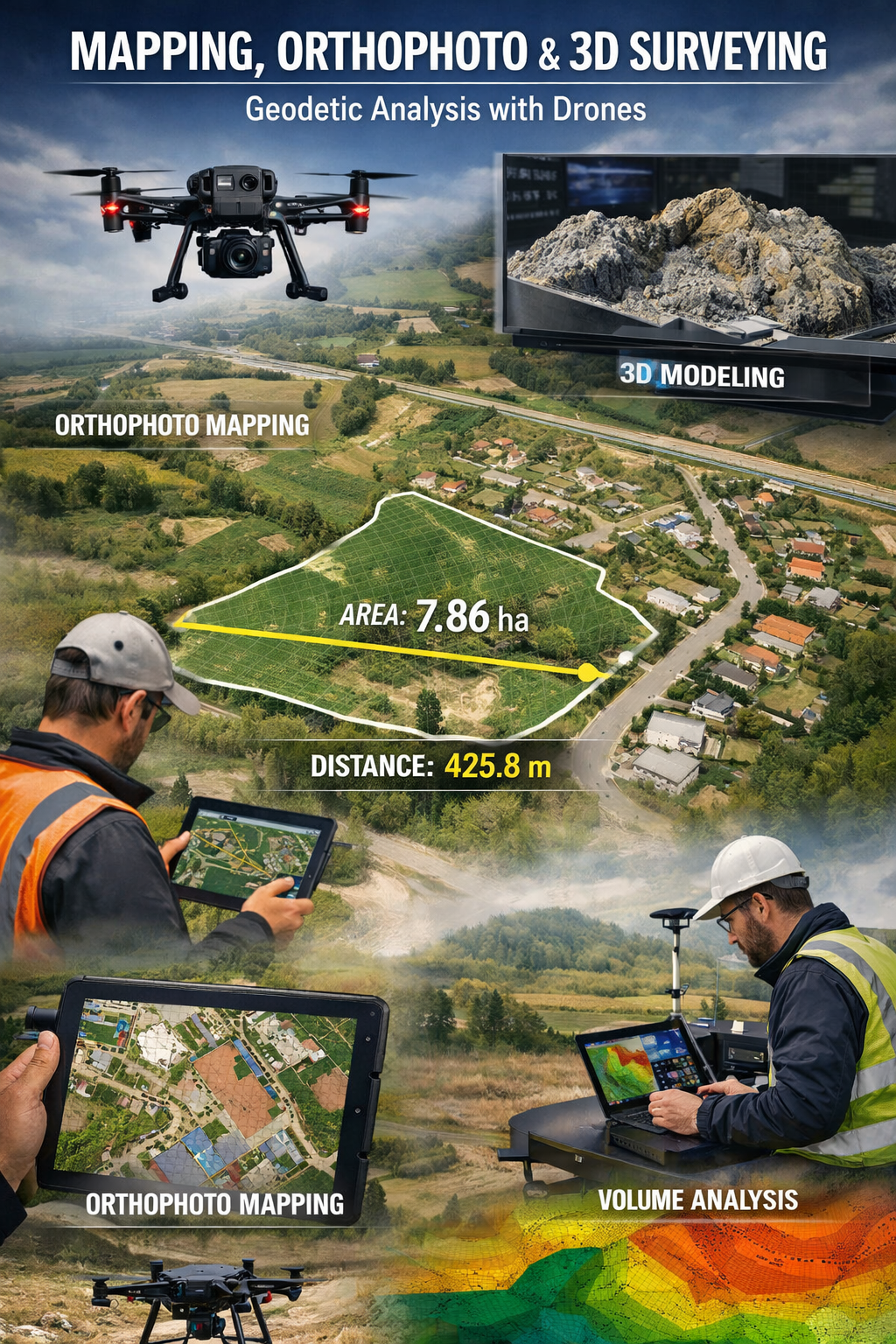
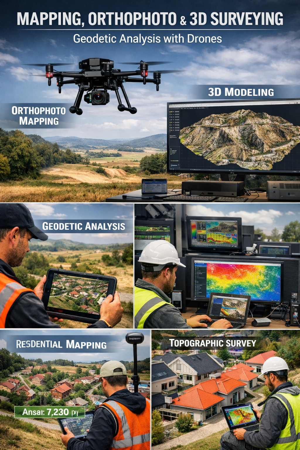
- Orthophoto surveying with drones – creation of high-precision orthophoto maps with georeferenced aerial imagery
- Geodetic surveying with drones – accurate terrain measurements using GNSS RTK/PPK corrections and intelligent point cloud processing
- 3D modeling and digital terrain models (DTM/DSM) – development of photorealistic 3D reconstructions of terrain, buildings, construction sites, and structures
- Mapping and planning – visualization, measurement, and analysis of terrain, objects, and changes with high accuracy, applicable across various industries
- Calculation of areas and volumes – with modern technologies, almost any type of area and volume can be calculated – agricultural land, water surfaces, buildings, roofs, and more.
Additional Capabilities and Extended Services
In addition to the core services, X-Sky Dynamics offers extended capabilities that significantly enhance the value of the collected data:
- Creation of Digital Twins of objects and terrains for further analysis and management
- Generation of contour lines, cross-sections, and longitudinal profiles for engineering projects
- Change detection analysis – automatic identification of differences between multiple surveys
- Volumetric analysis (cut & fill) for construction and mining activities
- Integration with BIM environments for synchronization between real-world conditions and project documentation
- Capability for time-series analysis and long-term monitoring of assets
- Development of interactive 3D platforms for visualization and remote access to data
- Preparation of datasets for institutional and legal purposes (documentation, reporting, expert assessments)
- Automated extraction of terrain characteristics – slopes, aspect, drainage patterns
- Support for investment analysis and feasibility studies using real spatial data.
Applications and Target Sectors
- Construction and infrastructure – planning, progress tracking, quantity calculations, densities, volumes, extraction of contour lines and profiles
- Agriculture and forestry – creation of precise maps of cultivated areas, analysis of slope, soil, and drainage, timber inventory
- Property management and cadastre – delineation of property boundaries, surveying of restricted or hard-to-access areas, creation of cadastral layers
- Damage assessment and insurance – documentation of disaster impacts (floods, fires, landslides) with georeferenced imagery
- Mining and extraction industries – volumetric calculations of excavations and embankments, monitoring of open-pit mines and stockpile areas
- Urban planning and architecture – planning of development, urban analysis, 3D presentation of projects
- Environment and disaster management – monitoring of erosion, runoff, fire risks, environmental damage, and crisis prevention.
Extended Applications
- Energy sector – analysis of routes for power lines, solar parks, and wind farms
- Transport infrastructure – analysis of road surfaces, railway lines, and transport corridors
- Water management structures – monitoring of dams, levees, and hydraulic infrastructure
- Industrial complexes – digitalization of production facilities and logistics zones
- Security and control – monitoring and analysis of critical infrastructure
- Maritime and port operations – mapping and analysis of coastal and aquatic zones.
Technological Advantages
High-Precision UAV Systems
- Industrial platforms with photogrammetric cameras
- RTK/PPK positioning ensuring geodetic accuracy up to 1–2 cm
- Capability to use LiDAR for dense vegetation or highly complex terrain.
Processing and Analysis
- Generation of orthophotos, digital surface/terrain models (DSM/DTM), point clouds, and 3D meshes
- Integration with GIS, CAD, BIM, and other professional formats (GeoTIFF, OBJ, LAS, SHP, etc.)
- Ability to create animations and simulations of changes over time, including mission comparisons.
Advanced Analytical Capabilities
- Automated terrain and object classification
- Extraction of geometric and structural characteristics
- Analysis of densities and spatial relationships
- Support for multi-layer GIS analysis
- Ability to combine multiple data types (visual, thermal, LiDAR).
Flexibility and Efficiency
- Significant reduction in time and cost compared to traditional surveying methods
- Access to hazardous, hard-to-reach, or restricted areas without risk to personnel
- Capability for rapid deployment and data acquisition in emergency situations.
Why Choose X-Sky Dynamics?
Licensed surveyors and operators with real-world field and industrial experience; High-end industrial drones with integrated navigation and sensor systems; Precise data processing and result delivery – ready for institutional, legal, or project use; Ability to execute customized missions based on specific client requirements; High productivity – combining field efficiency with expert-level data processing and analysis.
Additional Value
With our solutions, clients receive not just raw data, but structured, analyzed, and visualized information, ready for direct application in:
- strategic decision-making
- resource optimization
- project execution control
- risk reduction
- operational efficiency improvement
Get in Touch
[ CONTACT US ]