/ SERVICE #06
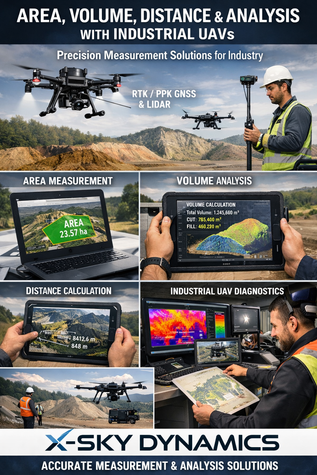
Measurement of Areas, Volumes, Distances and Analysis with Industrial Drones
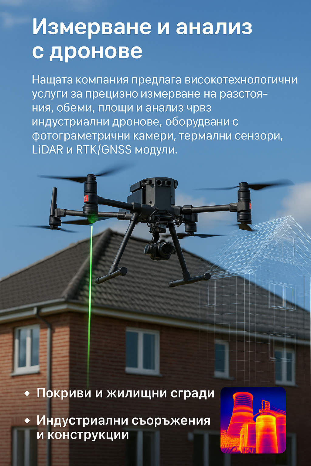
Measurement of Areas, Volumes, Distances and Analysis with Drones High-precision measurements, monitoring and diagnostics through modern UAV technologies photogrammetry, LiDAR, thermal sensors, and high-precision RTK/PPK GNSS technologies creation of 3D models and visualization ready for use by contractors
Through carefully planned aerial missions and subsequent data processing, we create a detailed and objective representation of the real environment, which enables not only measurement but also in-depth analysis of the condition, dynamics, and changes in various objects and terrains. This service is significantly faster, safer, and often more precise than traditional methods, while at the same time providing visual and digital results ready for direct use in engineering, construction, and management processes.
What We Measure and Analyze
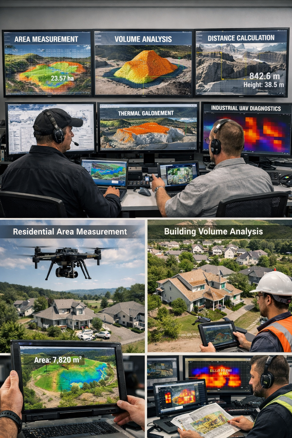
Roofs and Residential Buildings
- calculation of areas for repair, replacement, or construction of roofs
- analysis of slopes, drainage, and structural characteristics
- detection of defects – leaks, damage, thermal losses
- creation of 3D models and visualization ready for use by contractors
Industrial Facilities and Structures
- measurement of volumes of silos, tanks, warehouses, and bulk materials
- analysis of deformations, displacements, and structural changes over time
- thermal diagnostics of facilities (overheating, insulation issues)
- monitoring of technological processes and loads
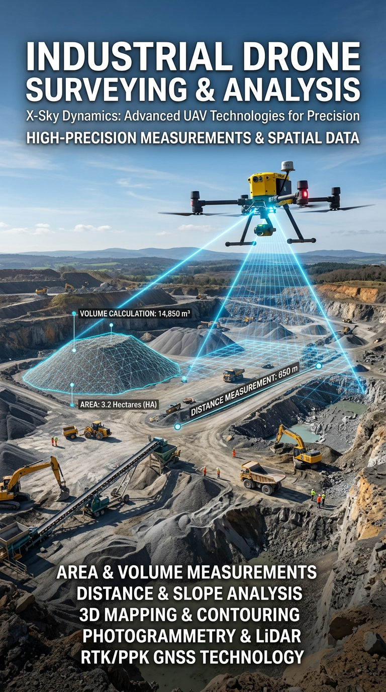
Construction Sites
- volumetric calculations of excavations, embankments, and concrete structures
- tracking construction progress through comparison of periodic surveys
- control of execution against project data
- analysis of terrain and structural stability and deformations
Forestry and Agricultural Areas
- calculation of areas and changes within them
- analysis of terrain, moisture, and soil condition
- assessment of vegetation, yields, and plant health
- monitoring of changes due to climatic or human factors
Marine and River Environments
- mapping of coastal and port areas
- measurement of areas and volumes of structures and infrastructure
- monitoring of shorelines and erosion processes
- analysis of pollution and substance dispersion
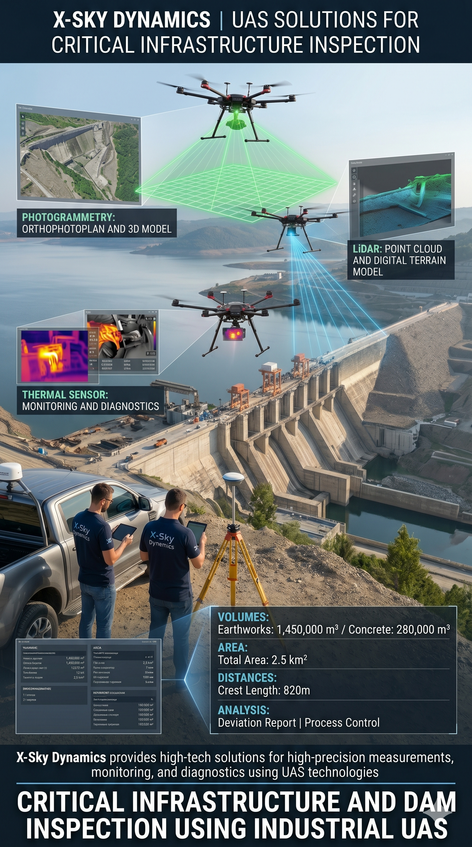
Telecommunications and Infrastructure Objects
- measurement of heights, distances, and geometry of towers, bridges, and antennas
- detection of deformations and structural deviations
- analysis of safety and condition of facilities
- support in planning and positioning of new structures
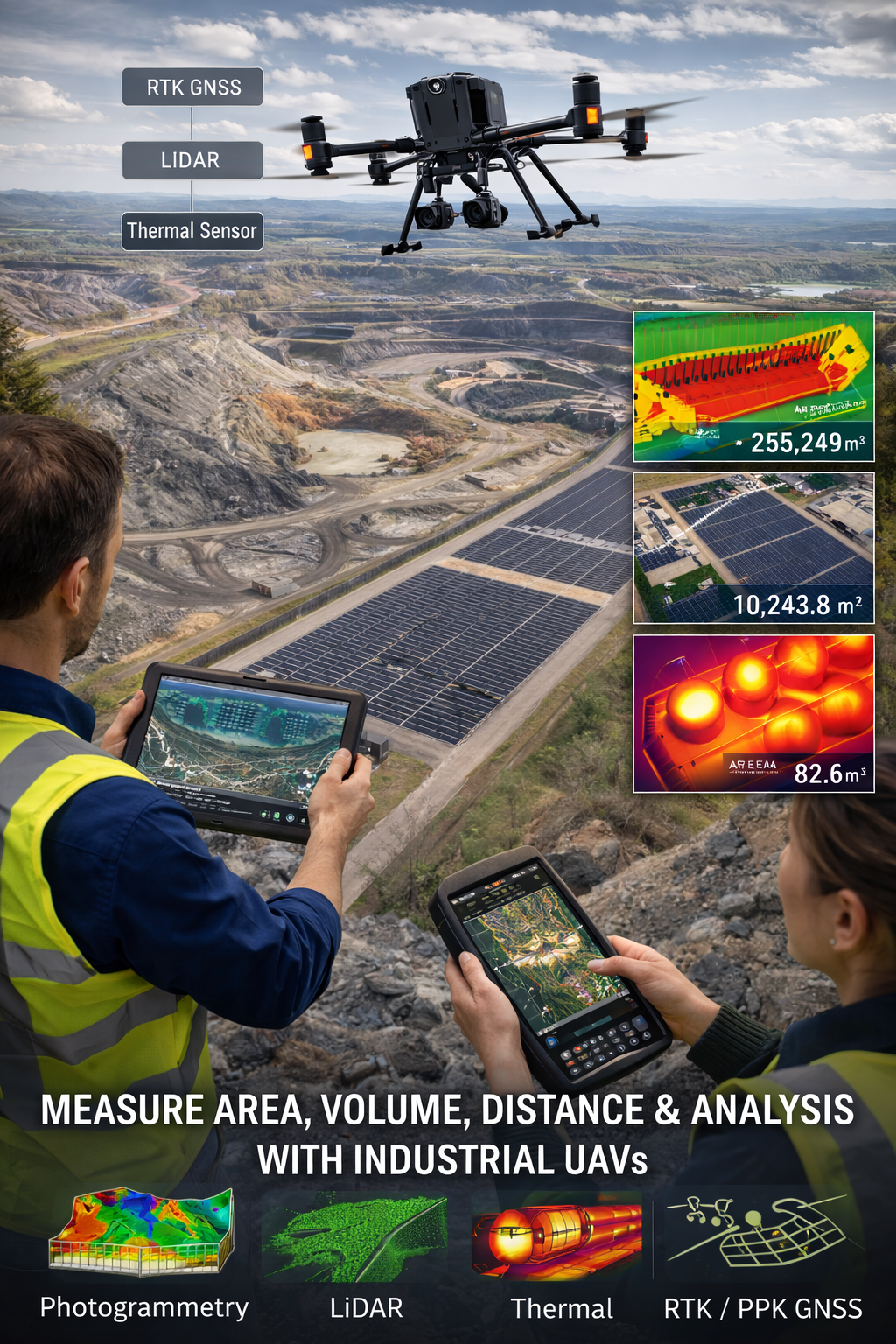
Extended System Capabilities
In addition to standard measurements, our solutions enable:
- high-precision volumetric analysis (cut & fill) for construction and mining activities
- real-time stockpile management and inventory calculations
- deformation analysis and monitoring of settlement, subsidence, and displacement
- comparative analysis between different time periods (time-series analysis)
- thermal detection of hidden defects and anomalies
- automated counting of objects, equipment, or resources
- creation of digital twins of objects and terrain
Technological Capabilities
- Real-time measurements – areas, volumes, temperatures, and changes
- Accuracy up to 1–2 cm through RTK/PPK GNSS systems
- LiDAR and photogrammetry – operation in complex and forested terrain
- Thermal analysis – detection of defects, losses, and risks
- Visualization in 2D/3D models – ready-to-use results
- Monitoring of dynamic processes over time
Client Benefits
- Speed – large areas measured within minutes
- Precision – engineering-grade accuracy
- Cost optimization – reduction of fieldwork expenses
- Safety – elimination of risks for personnel
- Clear visualization – easy-to-understand results
- Traceability – monitoring of changes over time
Formats and Integration
All data can be delivered in formats tailored to client needs:
- CAD / GIS / BIM compatible files
- 3D models and point clouds
- orthophoto maps
- Excel, PDF, and analytical reports
- interactive web platforms
- JPG files
Applications
- Agriculture – resource optimization and area analysis
- Industry – monitoring of warehouses, facilities, and processes
- Construction – quantity calculations and project control
- Municipalities and institutions – infrastructure planning
- Private clients – properties, roofs, yards, and buildings
Conclusion
Measurement using industrial drones is a modern and reliable method that combines precision, speed, and safety. It allows not only accurate determination of areas, volumes, and distances but also in-depth analysis of the condition and changes in objects. This technology enables better planning, more efficient resource management, and informed decision-making in both large-scale industrial projects and everyday applications.
Get in Touch
[ CONTACT US ]